San Andreas Fault in California USA and north west Mexico. Article Jan 20, 2016 more updates eventually, page in progress, updated Aug 21,2017. I have not seen the movie but would like to. MORE INFO AND PHOTOS BELOW

the "North American Plate" goes from California to Iceland where it is volcanic. There are signs of former volcanic activity at Bowling Ball Beach just south of Point Arena, where there are large round rocks taller than people, that were once spurts of molten lava, 2 miles from the fault line (quite a range for lava).
 The west side slips down, and stays like that for 20 minutes? 2 hours? rarely a couple of days; and then goes back to normal height, as if nothing ever happened. It also can open up like a pipe trench, during a quake with both sides shaking, people fall in...
ZOOMABLE GOOGLE MAP WITH FAULT LINE:
OPEN THIS MAP, IT WILL OPEN ANOTHER WINDOW SO YOU CAN STILL READ THIS PAGE
http://www.thulescientific.com/san-andreas-fault-map.html
Owing to wiggles in the fault line, portions of the thin red lines can be more than 100 ft from the fault.
But most of what I have personally witnessed, is quite accurate.
OOPS, THE WEB SITE NO LONGER INCLUDES POINT ARENA THRU CASPAR CA
THIS OOPS PUTS A BIG DENT IN MY WEB PAGE. As this article covers my personal experiences in the Mendocino area, but also included, I used to live on the Gualala ridge off Old Hwy Road, romerly Old Stagecoach Road, just north of the Gualala Airport. And all of that was just west of fault, still listed on the map (not omitted)and its the same thing, west side lowers from time to time, then goes back to normal. Fish Rock Road used to continue east of the ridge road, and people used to walk down there or drive down there, and it also blocked the road by the river road which goes from the town and coast, eastward, crossing the north and south forks of the rivers which are just the San Andreas (as are the lakes east of SF)
They fixed the Satellite View, but then REMOVED a portion of the fault, anything North of Point Arena. The reasons for the removal are unknown. It always was listed with a Thiner Red Line than the rest of the fault, perhaps they think its a sub section, but it has the same properties as the rest of the San Andreas Fault, which is not like other faults, it is THE TECTONIC GAP between tectonic plates. The properties include the Pacific Plate SINKS from time to time, etc. I have seen the same things at Gualala (listed on the map), east of Santa Cruz, the 15 freeway thru Cajon Pass, all those locations get BLOCKED when the Pac;tifc Plate sinks.
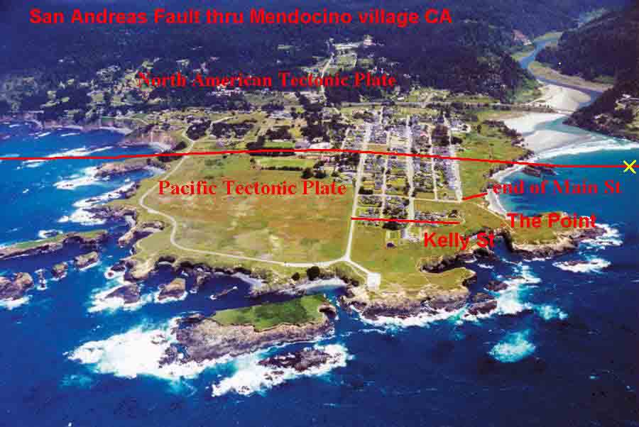
The same with the recently OMITTED (2019) portions of the coast north of the Navarro River, both north and south of Van Damme State Park at Little River (the fault goes thru the local small market at Little River, And right thru Mendocino village, as you face the Mendocino Hotel, just to the left, underneath the balconies (they collapsed when I was a kid, they now have construction to hold it better), then it goes northward, parallel and just east of Kasten St, just east of the Baptist Church, just east of the Packard House (the residents of that house and the house east of it were both artist friends and used to wave to each other when the pacific side went down), then it goes thru the high school cutting off access to the cafeteria and the west hallway and thru the counselors office, and a small portion of what was the typing room in the 1960s. Then it goes just east of some windbreaker trees at the high school baseball field (previous football, but they have a new field also), then north of the playfield there is a house, and it goes just west of the house, maybe 10 feet, then continues northward parallel to a dirt road and right next to some public restrooms, out to the north bay then back to land at Point Cabrillo, where it once went thru a house (now removed) that when the pacific side went down, the roof caught on some rocks on the east side and lifted the entire roof. There are buildings on the fault that incorporate and accommodate the sinking of the pacific plate. Such as the high school itself has some special features built in. The sinking tends to be SEASONAL, certain times of year are more prone. I think they should show more concern for the students, many have fallen into the crack, inside the building, the safety precautions are not enough. But the map continues to show the rest of CA. and they got the Satellite View back.
The SATELLITE VIEW IS (was) DOWN, non-functional at this time
AND Tectonic Boundaries are no longer shown on Google Maps
and Tectonic Boundaries are no longer shown at earthquake.usgs.gov
The San Andreas Map was previously shown at geology.com
The San Andreas Map is now shown at ThuleScientific.com but the Satellite view has since gone non-functional
CENSORSHIP BASED ON IGNORANCE & FEAR (and COST$$$): I think it is Censorship due to the unusual nature of the fault. Its like "Hide California's Shame", or perhaps they don't want to do something about it so they want to hide it. I lived in the town of Mendocino village and the fault goes right thru town and thru the high school, and when the crack would open, then go back to normal, a man with a suit and tie (in the redwood forest) would go all around the area with a black box with two metal plates on top, urging everyone to touch both plates "you wont feel a thing" but you won't remember a thing after the voltage. So they are in the habit of trying to hide it, when it is safer that people are informed. I have been writing US Senator from CA Dianne Feinstein regarding possible moveable bridges or moveable ramps going over the fault, so people are not blocked for hours. I have written Google Maps requesting their cooperation with Thule Scientific for the good of the people, but Google has taken a wrong turn with censorship, when I search, they have saved what I looked for before and refuse to show it to me again, they know what I am looking for and refuse to show it to me, its worse that the Communism and Iron Curtain which I learned about as a child.
One used to be able to see the famous tectonic gaps: around Guantanamo (natures security), the location of the 150 foot tsunami in Alaska 1958? used to show the tectonic gap going from sea to land then back to sea with the actual gap at the end of the bay where the tsunami occured. Some of the lines at Google Maps and USGS.gov did not properly show the Mendocino area, which they finally proved years ago. But those lines all over the world are important to people and important to those who sail the sea. Three tectonic gaps meet just east of Puerto Rico could be the reason for the Bermuda Triangles missing ships?
Here is a Map of the San Andreas Fault and the closer you are, the more likely and stronger the power of the quakes. This map is Satellite and Zoom-able Google maps you can zoom in and see it go right thru Mendocino High School 150 miles up the coast from SF. It also goes thru Del Rosa and North Park just east of Cal State U San Bernardino. And it appears to go right thru a Walmart Supercenter 4210 E Highland Ave Highland, CA 92346 (sometimes the red line can be off a few feet, ask Walmart).
Quote: "The location of the San Andreas Fault is shown on this map. Its trace is marked by red dots connected by thin red straight lines. The positions were measured from professional geological maps, primarily those of the United States Geological Survey, California Geological Survey, Dibblee maps and geological literature. The red dots are generally on the trace or within about 100 ft of it (true ground distance). Owing to wiggles in the fault line, portions of the thin red lines can be more than 100 ft from the fault."
Which explains why Highway 1 north from the Navarro River shuts off the road for a much shorter stretch than shown on the map. Once at the top of the hill, Hwy 1 turns north, at that point it crosses the fault twice in around 2 car lengths, I have been stuck there multiple times (listed in text below), but the map shows more than 2 cars lengths?, did they move the road? or a wiggle in the fault?.
Also, north of Mendocino high school is a play field then some trees then a house right on the fault, but if its the same house, the fault is actually around 8 to 10 feet west of the line marked. But most of this is very accurate, at least the Mendocino village area is. Including the high school, I know right where it goes, so do the students who went there.
I remember as a kid when the Mendocino Hotel balcony on the west side collapsed during seismic activity. I suggested they rebuild but put all the force of support connected to the hotel on the east side of the crack, then when the west side goes down a few feet, it wont affect the balcony. I was real smart for a little kid, they mocked me but I was able to fix things, get the car going, etc. when they couldn't and had given up all hope. THE MAP shows the crack west of their extended dining room, but I remember the crack to be a foot or two west of the crack, not the full dining room, and you can see in the sidewalk where that is. Its nearly flush with the hotel.
SEE ANOTHER PAGE LIKE MINE ABOUT OTHER LOCATIONS ON THE FAULT: including: SF, Marin, Santa Cruz, San Juan Bautista.....
http://www.rocdoctravel.com/2016/03/the-san-andreas-san-francisco-area.html
GEOLOGY.COM MAP IS DOWN (June 21, 2018) use the THULE link above
http://geology.com/san-andreas-fault/
BUT THEY ALSO HAVE MANY GOOD QUAKE RELATED ARTICLES including historical quakes of California.


This portion sinks due to lava underneath being transferred eastward. I lived 2 miles east on Little Lake Road which is on the Ridge between rivers and it used to sound hollow underneath (followed by quake activity).
The FAULT LINE CRACK OPENS UP FOR 2O MINUTES TO 2 HOURS OR MORE
SOMETIMES THE PACIFIC SIDE OF THE CRACK LOWERS A FOOT TO SEVERAL FEET
Geologists are not concerned about this movement, they are concerned with North South movement, the west side goes north and the east side goes south "The rate of slippage averages about 33 to 37 millimeters (1.3 to 1.5 in) a year across California." wikipedia, and larger slippage occurs with large quakes. But the opening and closing and raising and lowering is not of any concern to geologists.
OR OPENS UP TO THE SIZE OF A SEWER PIPE TRENCH
THEN IT CLOSES UP AGAIN AS IF IT WAS NOT EVEN THERE
IT IS VERY DANGEROUS TO PEOPLE WALKING OVER THE FAULT AREA
IT GOES THRU PEOPLES HOUSES AND SCHOOLS: Mendocino High, and Point Arena High parking
IT BLOCKS MAJOR ROADS FOR 20 MINUTES or HOURS (common) UP TO DAYS (rare)
Admittedly I am superstitious about it, due to the timing of the events I have been thru, and have noticed, even if superstitious; if you are stuck on the road because the crack is open (Cajon Pass, Navarro Ridge...), smoke a joint, which is now legal in CA (pull to the side of the road of possible), for me it has always worked, the crack opens, I get stuck, I wait and wait and wait, finally smoke a joint, then it goes back, try it, carry an emergency joint or two. When I was a kid in Hollywood, Thrifty Drug stores used to sell very cheap First Aid Kits with a joint of Sativa (scary kind, while Indica is less scary, I prefer Indica but like Sativa too)
Keep in mind, that it is not just a fault line, it is a Tectonic gap, between the Pacific plate and the North American plate
CRACK OPENS OR WEST SIDE LOWERS:
The West side of the San Andreas, the Pacific side, drops a foot or more, a few feet during seismic activity, and sometimes opens into a trench, looks like plumbers laying out pipe kind of trench, but its a crack deep into the earth, people fall in, and I was swimming in Mendocino Bay and the crack goes right thru the bay, and while swimming the water swept me in, but I lived thru it (witnessed by on duty officer and others). Fault line movement blocks traffic on the 5 at Gorman, and on the 15 in Cajon pass (between Glen Helen and Victorville) for 20 minutes to a couple of hours (rarely for days) but it goes right thru peoples homes all thru CA.
The San Andreas is different than other faults in that it eventually snaps back into place.
LEFT SIDE = North American Tectonic Plate, RIGHT SIDE = Pacific Tectonic Plate.
NOTE THAT THE RIGHT SIDE IS LOWER BY AT LEAST ONE FOOT
The west side slips down, and stays like that for 20 minutes? 2 hours? rarely a couple of days; and then goes back to normal height, as if nothing ever happened
This photo of the 1906 S.F. Quake in Marin County (north of SF), shows the left side (north american tectonic plate) up around a foot or so above the right side (pacific tectonic plate), thus we are looking south in the morning. If you had a paved road over that, you might not be able to drive up a foot, as in Cajon Pass Hwy 15 from Los Angeles / Glen Helen going uphill towards Victorville. I was stuck there.
FRAIZER PARK POND WATER MISSING?
I have heard this has happened just west of Palo Alto and south of San Francisco, those lakes are the San Andreas Fault, and I heard that the water disappears then re-appears? with seismic events, I will check into more of that later, meanwhile....
Frazier Park Pond missing
https://www.youtube.com/watch?v=mDt_Rx-r4Ag
Frazier Mountain Park Pond continues to disappear sept 2016
https://www.turnto23.com/news/local-news/frazier-mountain-park-pond-continues-to-disappear
Frazier Mt Park and Pond are around 2 miles west of Gorman and Hwy 5, and in Frazier Park just west of the Post Office. Just south of the east west main road where it reaches it northmost curve, looking at it a couple of years ago, the water reached the crack at that time, now there is hardly any water
ZOOMABLE GOOGLE MAP WITH FAULT LINE:
http://www.thulescientific.com/san-andreas-fault-map.html
AND note the zig zag sidewalk to the right of the lake, probably where the crack opened up at some point? They were probably wondering who was doing construction? (this happened in Mendocino CA north of the high school, someone put in a sewer trench? my grandmother was handling the rental and wondered who did that? a friend said "I used to dig these..." and jumped in, no bottom, good I was there to help pull him out, its DEEP).
I am wondering of the Frazier Park Post Office has any tales to tell? what with the crack running right thru the post office (the map is not always exact, it could be right next to the building, but they must know about it, "it is better this way, no feeling, no pain, soon you will be amongst us", unless they decline from contact
CLICK HERE FOR GOOGLE MAP THEN PLACE "STREET VIEW MAN" TO CENTER OF ROAD, LOOK FOR BLUE "LITTER REMOVAL" SIGN, just across the road from that

And VERIFY FAULT LOCATION just west of Gorman / Hwy 5 with http://www.thulescientific.com/san-andreas-fault-map.html
The San Andreas is different than other faults in that it eventually snaps back into place.
GOOGLE MAP STREET VIEW OF THE MENDOCINO HOTEL yellow cream color: note where the sidewalk goes downward towards the left of the hotel, then a change in sidewalk is the fault location. I recall viewing the crack beneath edge of the hotel which is on the North American tectonic plate, but the Pacific side (garden dining area) goes down, so they re-supported the balcony to be able to rest entirely on the North American Plate (is what I think they did, I was just a kid, and that was my idea of a fix), and another time I was riding my bicycle as a teenager in front of the hotel (in this view right to left) and someone was waving his arms in the air shaking his head "no no no....", but I had no idea and approached to ask and went over the edge of around a foot on my bicycle but the bicycle and myself were all ok.
I am seeking Photos of the Crack Open, I have seen it many times myself; but I know there has been cover up over it. Including, after major seismic events, someone official would go around with a portable electro zap machine asking people to touch both plates, and that I wont feel it, and some people have hid in the woods and with neighbors and friends to avoid this. So I am guessing that photos are hard to find, and I have not been able to find many. Especially with the Pacific Plate (west side of the crack) lowered a foot, or 3 feet, or way more, which is how California gets its Tsunamis, the land west of the crack goes down and the water appears to rise but its actually the land sinking, but don't panic, it always comes back, but has rarely lasted more than a couple of hours (a few days I recall, once that I remember). But if your in a Tsunami, when the water recedes back to the ocean, hang on to land, a tree, a house. It is also hard to find San Andreas crack photos due to the movie (which I did not see, but obviously some photos are from the movie and are not real). I am seeking real photos.
IF YOU HAVE ANY PHOTOS OF THE SAN ANDREAS FAULT WHEN OPEN or damage right afterwards before being repaired, please post them directly to my
https://www.facebook.com/archure1
along with any helpful info please, name, day month year if known, location, do you want to be mentioned. Posting directly to Facebook Page is the fastest way to find me, as I rarely get to my long list of emails from 1,400 friends who say "hi", "hi", "hello?"
There are different kinds of TSUNAMIS. using non-official terms
1) SUDDEN IMPACT: An earthquake on the edge of the Pacific generates a seismic wave that turns into a Tidal Wave, a large taller and much faster moving wave, which strikes other locations storming on to the land briefly then retreating. Sometimes this quake (usually on or near a tectonic gap) is only just off the coast such as in Japan.
This Video talks about two types of Tsunamis both listed above, distant and nearby; but does not mention the gradual lowering which happens in their area. I am guessing they officially are not going to say anything. However if you talked with the locals, then follow up by talking to the Fire Dept at Stinson Beach or the Coast Guard Station in that area or Point Arena or Point Cabrillo, they may or may not say something, but the locals would know about it, or herd tell.
https://pubs.usgs.gov/gip/95/
2) TEMPORARY GRADUAL LOWERING one side of plate: The kind I am talking about on this page. On the California coast, due to subduction (magma lava beneath the Pacific plate in excess, flows underneath the North American plate, in the process, the Pacific side of the plate goes down a foot, maybe 3 feet, sometimes drastically more and stays that way for a few hours, at which time I have seen large waves crashing along Heesers Drive in Mendocino when the Sheriff or Fish and Game gave us a quick ride up the hill. And I have been more towards The Point (S.W., south of Kelly St) when the water has risen up to the houses on Kelly Street in Mendocino, and in those cases it was a rather gentle rise, no big wave, just a slow rise in of the water, hardly any waves; and it stays that way for hours (variable) then goes back to normal when the water rushes back to sea hang on to something, I saw someone who didn't it looked real fun but I don't think they lived (once they got to the rocks by the sea).
Tsunami Areas affected by the lowering of the Pacific Plate: Little River CA, Mendocino, Point Cabrillo, Caspar, Shelter Cove, Point Arena, Gualala, Fort Ross, Point Reyes Seashore (maybe they have some info? back later), and oh the tales I have heard of Inverness and Bolinas, Then south west San Francisco the fault turns inland, and as to the nature of the Tsunamis south of that point, I am not certain, but I have heard from several people around Monterey CA, Venice Beach CA, Hermosa Beach CA (where I used to live, in an official Tsunami Zone) it has apparently gone up over the large beach to beach houses (and with a slow rise). San Diego and Baja Mexico may be Tsunami Zones? San Diego is at least 30 miles from the actual fault which goes into the Gulf of California. I tend to think that most of what I have heard on these sound like slow rise of water, but if there is stormy ocean, that can bring big waves. But this type, not the sudden one or two big fast tall waves. I am talking Water Rise type here on this page.
When the San Andreas Crack is active, I have personally seen the ocean water rise to beyond where the Blue Line goes, up to the end of Main St (right side) and I know it has gone further. This was around 2 feet wading water for the blue line. However, I was in a house on Kelly St when the water rose to the top of the front door, and the house was elevated several feet, and in another house (not elevated) with around 4 to 5 feet of water.
The Red Line is the San Andreas Fault, the blow hole and Kelly St are on the west side of the crack. Deep in the earth, the molten lava from the west side, pacific side goes downward and underneath the eastern side, causing the west side to sink, and possibly the east side to rise (which ever side you are on, it seems to be the other side that is moving, bur the ocean does rise as proof of the west side sinking, 20 minutes, 2 hours? or longer?). This is called a CONVERGENT boundary https://en.wikipedia.org/wiki/Plate_tectonics#Types_of_plate_boundaries
and MORE SPECIFIC
https://en.wikipedia.org/wiki/Convergent_boundary
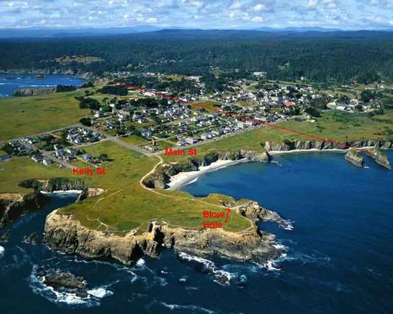
The RED LINE is the San Andreas Fault thru town.
Note ocean water rise locations in Red: Kelly St, Blow Hole, and the west end of Main St. I was with Pete Sinclair, he was driving around the Blow Hole, having fun, at night, in very heavy rains, and a quake happened, and the water was rising, and I said Pete, we have to get out of here, drive back to Kelly St, but no, he was blowing his mind, so I got out and walked northward on the Point Mendocino Trail and he eventually got out and walked, as the water was up to his generator (towed the next day). We walked to Roberta Whiteside's house across from this house on Kelly St, all in 1 to 2 feet of water. From there I carried Roberta on my back, and we hiked to the end of Main Street in 1 to 2 feet of water, and then up Main Street is where the water rise ended.
San Andreas Fault meets the Pacific, south side of Mendocino hiking trail
BELOW: on the left it says Pacific Tectonic Plate on the left side, that is all Heeser drive area where I had to swim to up the hill near the Fault line. Towards the Art Center (above the word Plate right side). Above Heeser's there are 2 playing fields for the High School, the playing field above (east of) the fault line has Trees growing around it, to the left of the field and trees there is or was a small house where Sharon O'Shea lived, and the fault line was right behind her house and looked like a sewer pipe trench. A man went in the fault, despite our warnings, the ground shook and he fell in deeper and it closed up on him. This was reported immediately, but the crack was closed solid, and the authorities did not intend to dig. Some time later (days?) a friend and I were at the same location but west of the fault line, the ground shook, the west side went down maybe 8 to 10 feet and we saw a man (the man) clutching on to the side of north american plate, it looks like a dirt and rock wall straight up. He was not responding, we were able to pull him down (peeled him off the wall), and he was cold and I tried talking to him, he jumped up and attacked my friend with such battle, but not me, and I said why don't you relax and he laid down. He was an actual zombie. So we dutifully reported his body found and the location.
PHOTO: LEFT = NORTH /// DOWN to the OCEAN is WEST /// UP to INLAND is EAST /// RIGHT = SOUTH
The RED LINE is the San Andreas Fault thru town. The lower portion of land on this photo is Heeser Drive, and at least twice I have been down there when a quake happened and the water started to rise. Local Law Enforcement gave us a ride up the hill, and another time I got caught in the water rise but had sense enough to head up hill, swimming part of the way. On the Right Side in RED is Kelly St, I have seen the water at least 1 ft above ground level on Kelly St, and one time maybe 10 ft. On the right is The Point and Blow Hole (underground volcanic tunnels and fury of waves cause water spouts out of the Blow Hole). AND ON THE VERY RIGHT in the water, YELLOW X marks the approximate spot where the crack opened, the water rushed in, carrying me down into the fault, witnesses by local law enforcement, my grandfather, and a friend Steve Nelson who later went down at that location while surfing, he came up right away, his board followed broken into 2 pieces, I carried one half to his house. But when I was in the crack, I was trapped for what seemed like forever, the most difficult thing I have ever endured.
Heeser Drive meets San Andreas Fault, just to the left of the dirt driveway and parallel to the dirt driveway, and you can see the pavement rework
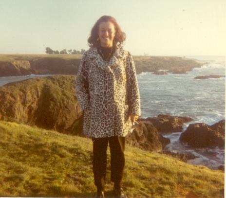
My mom Lyda, just south of Kelly Street on the trail to The Point and Blow Hole, on the western edge trail. Point Mendocino Trail
TECTONIC GAP LOCATIONS
SOUTHERN CALIFORNIA AREAS UNCLEAR: south of Salton Sea and South of Eureka
The fault goes thru the east side of Salton Sea, but the Google map stops there, however there are many other maps at usgs.gov which show fault lines. The big debate is, does it go thru El Centro then south? or is it just west of Yuma Az? There is continual movement in the El Centro area, but on rare occasion, there are extreme shakers at Yuma. It seems like a split fracture thing. My moms good friend Herbie Mann, took me for a ride in his sports car to where the San Andreas Fault meets the Gulf of California. He knew right where it was, I am not quite certain where? but I think enough people know about it, and you can see the shift on both sides of the fault.
OTHER TECTONIC LOCATIONS AROUND THE WORLD:
There are plates all around the world, and other areas of fault line gaps including off the coast of Japan (the cracks off the coast open, the water rushes in causing ocean waters to rush to the area, then the cracks close and spew out water = tsunami), thru the Philippines (water and land), between N India and Tibet, the Middle East (Israel, Jordan, W Syria, N Iraq, S Iran), just off the coast of western South America (quakes and tsunamis), Iceland (volcanic areas), etc, all earthquake zones, not that it cant happen other places, but thats the main areas.
* Tectonic Boundaries are no longer shown on Google Maps
** Tectonic Boundaries are no longer shown at earthquake.usgs.gov
HAS RUINED THIS PORTION OF THE PAGE, as the maps don't show the tectonic gaps
The San Andreas Map was previously shown at geology.com
The San Andreas Map is now shown at ThuleScientific.com but the Satellite view has since gone non-functional
The SATELLITE VIEW IS DOWN, non-functional at this time
CENSORSHIP BASED ON IGNORANCE & FEAR (and COST$$$): I think it is Censorship due to the unusual nature of the fault. Its like "Hide California's Shame", or perhaps they don't want to do something about it so they want to hide it. I lived in the town of Mendocino village and the fault goes right thru town and thru the high school, and when the crack would open, then go back to normal, a man with a suit and tie (in the redwood forest) would go all around the area with a black box with two metal plates on top, urging everyone to touch both plates "you wont feel a thing" but you won't remember a thing after the voltage. So they are in the habit of trying to hide it, when it is safer that people are informed. I have been writing US Senator from CA Dianne Feinstein regarding possible moveable bridges or moveable ramps going over the fault, so people are not blocked for hours. I have written Google Maps requesting their cooperation with Thule Scientific for the good of the people, but Google has taken a wrong turn with censorship, when I search, they have saved what I looked for before and refuse to show it to me again, they know what I am looking for and refuse to show it to me, its worse that the Communism and Iron Curtain which I learned about as a child.
This shows the TECTONIC GAPS AROUND THE WORLD so you can tell the difference between regular faults and tectonic gaps.
https://en.wikipedia.org/wiki/Plate_tectonics#/media/File:Plates_tect2_en.svg
THEN select an area at
http://earthquake.usgs.gov/earthquakes/
** Tectonic Boundaries are no longer shown at earthquake.usgs.gov
SUCH AS THESE SELECTIONS:
This map shows a Tectonic Gap is the Red Line going North to South (just like the San Andreas Fault) right thru Israel, Jordan, W Syria.
MAP SHOWING TECTONIC GAP LOCATION IN ISRAEL: This map zeros in on the Israel area.
http://earthquake.usgs.gov/earthquakes/eventpage/usb000khl6#general
** Tectonic Boundaries are no longer shown at earthquake.usgs.gov
MAP SHOWING TECTONIC GAP LOCATION IN TIBET: This map zeros in on the Tibet/N.E.India area. (the tectonic gap is the red line going east to west)
http://earthquake.usgs.gov/earthquakes/eventpage/us20002926#general
** Tectonic Boundaries are no longer shown at earthquake.usgs.gov
THE FUTURE:
"Those who do not learn history are doomed to repeat it." --George Santayana
Tall skyscrapers? 4 story apartment buildings? and the high rise buildings? semi-safe work buildings (always had my eye on the door and escape route), its too dangerous to live in L.A. or S.F. unless you live in a small one story house, and even then, you have to go into buildings, drive on roads. The people who design these buildings do no live nor work in them within 40 miles of the San Andreas Fault. Could they hold together? (long pause) they might. It could happen. Like that big quake in Japan where some of the newly designed buildings (much better than ours) swayed and nearly collapsed, but didn't, and I am very glad. So now I am in Las Vegas, 200 miles away from the San Andreas Fault, but I used to live next to it in Mendocino and in Gualala off Old Stage Road, right next to the fault and did I feel some big quakes
( "> <'?)
PART 2
This is a collection of postings to Facebook, so some of it may be redundant, but some has more info. I will try to come back and condense it maybe.
GOOGLE ZOOMABLE SATELLITE VIEW SHOWING QUAKE FAULT GOING THRU HOUSES.
Where the San Andreas Fault line is http://www.thulescientific.com/san-andreas-fault-map.html
Its not just a regular fault, its a gap between the North American Plate and the Pacific Plate https://en.wikipedia.org/wiki/Plate_tectonics
WITNESS: I am personal witness to fault movements while driving north on the 15 Hwy in Cajon Pass between Glen Helen and Victorville, the car in front was having a tough time with a crack and it raised up in front of me, going slowly I stopped, people behind me honked till they realized the ground in front was raised up by over a foot. I have also, around 4 times been stuck on Hwy 1, just north of the Navaro River, there the west bound road going west along the river, turns northward up the coast, right there, there is a loop in the road that goes right over the fault, then back again, and I was stuck there in a van of students (I was one) who knew of the issue and location and waited patiently (that's all you can do). Just north of Mendocino High School there is a house right next to the fault, and there was a quake, it opened up around a foot, and looked like a properly dug ditch for sewer pipes, is what I thought it was, except it goes down and down, its the gap between the North American Plate and the Pacific Plate, it goes to the volcanic level. Someone tried to go into the crack after something of little value and the ground shook again they fell in and the crack closed. As a toddler on Main St in Mendocino I was walking on the sidewalk during a quake and fell in, hung on to the side, and my grandfather pulled me out. It goes right thru Mendocino High School; and I have assisted in rescuing others during quake movements. In Mendocino, campers often camp in some big long sunken trenches because it is a natural shielding from the wind; please advise these campers that it could open and they could wake up gone.
DANGER: ABRUPT TURN friction potential:
Del Rosa and Highland, right on the crack, and especially Desert Hot Springs area where the crack does an abrupt turn; it also goes thru south San Francisco just south of Daly City and along the west edge of the South Bay. Most of the Bay Area is very close to the San Andreas, while L.A. is from 20 miles to 40 miles away from the fault, here in Las Vegas its 200 miles but I miss the ocean
LUCY JONES AND KATE HUTTON:
I was playing in a rock band at a free concert at Cal Tech and met Kate Dr. Kate Hutton (Earthquake Kate) and Lucy Dr. Lucy Jones and got to chat with them about earthquake prediction, which I used to be good at (astrology) when I lived close to the fault line
TRAFFIC JAMS TO AND FROM LAS VEGAS: Cajon Pass, the 15 freeway just north from th 215 and 210 where the San Andreas That is what hangs up traffic, when it opens a bit, the pacific side goes down around a few feet, and stays that way from 15 minutes to hours or rarely for days, same with Gorman and the 5 freeway
The San Andreas Fault goes thru Hwy 15 between Glen Helen and Victorville, slow down when you see the Hwy Patrol with flashing lights waving their arms, and thru Hwy 5 at Gorman, right thru the overpass. At Cajon Pass, it was dark, I was headed towards Los Angeles and saw yellow flashing lights, the right lane was nearly stopped, people were going slow, an officer waved his hand palm forward, up and down to his right, which I did not know if he meant Slow? or Stop, I tried to slow was nearly run into and went over the edge and told the officer on the lower end I was not sure if the other officer meant slow or stop with that signal? He scream "he meant STOP", I said well can I go now? he said "sure, go ahead".
CALIFORNIA SINKING INTO THE SEA: (for 20 minutes)
I knew some people who lived right on the cliffs of the sea, just south of Little River CA. with their house between the San Andreas Fault and the ocean. And the property would lower down a number of feet, and the waves in winter were big and would go up to the house (getting close). So I think that is what they mean by CA sinking into the sea, its just a few feet, and then corrects itself. Also note the San Andreas is around 25 miles east of Los Angeles, not right on the fault, and I don't think there would be a big hole in the ground in Los Angeles.
LIVING ON THE ROCKS AT LITTLE RIVER:
My grandfather had some friends who lived on the cliffs just south of Little River CA, Dudley Blanchard and his wife, and they had a samoyed dog Luba, and the fault was right behind their house, they were between the fault and the ocean. We went to their house, but they were gone? missing? but the fluorescent light fixtures were gone too? I think they moved and took the lights with them. This was south of Little River and I now see something just north of Little River named Blanchard House Inn? which is not the same place. This was on the ocean with a little cove (near Airport Rd).
DON'T CAMP IN THE SAN ANDREAS CRACK:
I used to tell campers to not sleep in the crack (it provides shelter from the wind, but sometimes opens up)
GUALALA:
I went to a private school in Gualala CA just off Old Stage Rd (west of the road), just north of the Airport, and the San Andreas is just east of the road. I remember one very very big shaker between Aug 64 and June of 66, sorry I don't have the date/year. I was told to not walk over there (N. fork of the Gualala River, no water, just rocks) but our neighbors the Dimitroffs were missing, and they used to walk over there on a regular basis????
AND the South Fork of the Gualala River (I once canoed down it, beautiful) is the San Andreas, and sometimes all the water disappears???? down the crack, is what I heard tell (did not observe it myself but heard that the Gualala River water has vanished abruptly). There are water reservoirs south west of San Francisco which are the San Andreas Fault, I don't know if their water disappears? North of Point Arena and Manchester the fault leaves land going north at Alder Creek.
SWEPT INTO THE CRACK BY TSUNAMI:
I was swimming in Mendocino village in the Bay just south of town and the crack opened and a tsunami carried me down, I found a cave, and was under water in the cave (with air) for around 28 minutes, but I was unable to get out till the crack moved again bringing a gush of water up, after being briefly pinned/squish between the Pacific and North American plates (worse than delays in Social Security versus people I owe, with me in the middle), once released by the crack, I was able to swim to shore. Where my grandfather and good friend Steve Nelson and the Hwy Patrol or County Sheriff was waiting, they all saw me go under, they all saw me come back, and they said it was 28 minutes. I think it was around 1964 or earlier??? should be documented (Hwy Patrol? or Mendocino County Sheriff?). The same friend Steve Nelson was surfing in the bay around 1968? or 1969? and a tsunami carried him into the crack only briefly, but his surfboard came back up in 2 pieces, I helped him carry it home, he lived next to the high school (near the crack again).
STUCK AT NAVARO at least FOUR TIMES: The Pacific side goes down sometimes. I was on Hwy 1, coming up from the Navaro River and it briefly loops over the crack, and when the Pacific side goes down, you get stuck there. One time with a van full of us kids (from the school in Gualala), one time with my mom, one time by myself, and one time by myself but another car behind me, honking their horn, I got out and pointed to the stone wall in the way of the road, explaining it might be 10 to 20 minutes, but sometimes it has taken a few days or a week? One time I was stuck there with my mom, and another time I was all by myself and not worried about it, thanks to the first experience the school kids in the van
SUB FAULT? or map re-write inconsistency? The Google Map used the show the fault and road differently and more closely associated with my several experiences at this location, leading me to believe it may be a Sub Fault issue. The fact remains (that does not match the map) that the brief loop is much smaller. The Map shows at least a mile of road west of the crack (north of the Navaro river), but the loop that slides down hill was no larger than 30 feet by my memory. (however it does not feel as if it is sliding), its more like the other side is rising).
LIVING NIGHTMARE AT MENDOCINO HIGH SCHOOL
It goes thru the counselor's office in Mendocino high school (real nice lady), I was talking to her, I was in the hall, she was in the small cramped tight office, barely room for her desk. Sid Noyes came and put a pencil on her desk saying he was next (Fall 1970?) and the counselor was saying that with my shoulder length hair, I was putting a big gap between myself and society, making a big pendulum sweep with her arm in front of her, so I said, let there be a big gap, and made the same gesture, and the crack opened where we both had gestured, the pencil rolled off the desk and and bounced down and down and down. She was trapped in there, she did not want to jump, and I saw the maintenance man and got him, he got an axe to axe her out from the wall behind her (Home Ec), but it leveled out before he was done. If you knew Mr Godsey, the Maintenance Man at the high school, he was rather wild looking and had short red hair sprouting in all directions. Picture being in a Home Ec class, there is a brief earthquake, then a few minutes later this wild man in a jump suit (pajamas?) comes running in with and Axe, runs to the back of the classroom and starts axing the wall (to get to the counseling office), like the earthquake was not enough trauma.
And the crack also goes into the entrance of the Typing room, I think its underneath the teachers desk or next to it? I rescued my typing teacher who was stuck on the Pacific side while we students were on the North American plate. The classrooms where all on the North American Plate, but if you need from the North Hall to or from South Hall you either had to cross the crack twice or go outside in the rain (and I often did, and when I didn't it started up again). Or if you wanted to go from class to the cafeteria for the Pacific Plate Special? you had to cross from the North American Plate to the Pacific Plate
POINT CABRILLO:
Over towards Pt Cabrillo (north of Mendocino) it goes right next to the back of one house on the cliffs, so that when the Pacific side sinks, the rocks catch on the bedroom eve of the roof, and raises the roof (and in the rain). Looking at Google Maps, I think they tore the house down?
I was delivering things to a woman at that house (I think it was a map showing the thru roads and maybe some food), on behalf of my grandmother Miriam C Vashkulat aka "Mimi" who handled rentals (and wrote Meandering with Mimi for the Mendocino Beacon newspaper located around 50 ft east of the fault), and while delivering the paperwork, there was some quake movement, I go out to the car to leave, drive around the corner and there is a wall of dirt/rock blocking the road, so I back up, and try to find the right dirt road out? I could not find it, went back, the woman was just as confused and we called my grandmother on the phone, and I guess we must have eventually realized it was the San Andreas.
SAN ANDREAS? OR SIDE FAULT? SAN ANDREAS:
At that time, they were still trying to determine if that was it? or if it was out at sea? There are sub-faults. I used to sit on the cliffs of Mendocino, looking West, wondering how far out at sea the San Andreas Fault was? But some people said it was indeed, in town. It goes right next to the Mendocino Hotel (thru their garden area and dining room). Just north of the Hotel it goes thru a nice looking house (right underneath) that has a series of extended rooms added on, one after the next. Some people theorized it to be a cat house. It was a former Lumber Mill Town with lots of bars and churches. But I think it was placed right on the fault so that it was sort of like an emergency ladder?, one side of the complex on the east side of the crack, part of the long building on the west side, but I have not seen it in action. Then it goes north behind the Tibbins/Kenner building (Morris Boykoff Pharmacy for a while), and behind the Baptist Church, between two houses (the neighbors used wave to each other during quake movements) then up thru the High School and past what was Sharon O'Shea's house (Jazz singer pianist who ran a record store, Mama's Place). Then finally out to sea on the north side of town (you can get to the beach and rock at that location, I remember being warned about that location, but I myself have not seen movement there. I have seen movement on the South side of town while sitting on the cliffs (you can see on the map where that is, right where the trail splits).
MORE TSUNAMI
MORE TSUNAMI
Notice the black line gap along the edge of South America this line always appears at Sea, but I think it may go on land and they don't want to admit it, ie. highway with the crack right along the road, they just pave it over, and it behaves just like the San Andreas which is the Tectonic Gap. Also see the line above India between Tibet and India where there was a big quake a few years ago. Also see the Philippines and Japan and New Zealand, black lines (gaps) go thru those areas, and they get Tsunamis and Quakes too. In CA the west side of the gap goes down a foot or two, for maybe 20 minutes (rarely 2 days) then moves back. In the ocean, the cracks open a bit and water rushes in causing low tide, then it closes up and the water comes rushing out causing tsunami
Actually the west side sinks, but if your on the west side of the crack, it appears that the east side rises. I know this from my experiences in Mendocino with me on one side and friends on the other side, no mater what side, the other side appears to move. But in Mendocino by the sea, the west side and near the point (south west) the water rises. I was with my friend Pete Sinclair, who liked to spin donuts in his truck (spin around in circles in the mud and rain) but after a while the water came up the cliffs to where Pete was spinning around, I said Pete, we better head for higher ground, and he was just in a total state of amazement that the water would rise that high, along the cliffs there at the point? what is that? any Mendocino people around? maybe 14 feet or more? so I got out and walked, urging Pete to follow, and it reached the generator level and would not run, so he walked, we stopped by Roberta Whiteside's house and brought her along and headed for higher ground. Another time I was north of the point and the water was rising gently but then retreated to the sea rapidly and I saw someone riding with the water and told them to grab something hold on. And another time a friend and I were out at Heesers drive on the west end hiking around sitting by the sea and there was a quake and the water was really getting wild so we started to hike towards town and I think it was a Sheriff came along and gave us a ride, he was just coming to advise us, but then one is trapped on the west side of Mendocino and should not attempt to get over the crack, I have with a ladder but the 2nd person with me, the quake re-shook the ladder went into the crack and I grabbed the other guy, he was ok but the ladder?
TOPSY-TURVY is the word, it is wild
Out at sea, the black lines on the map are areas where ships can easily go down. I think the problem is, some captains might follow along the interesting water happenings and eventually not be able to pull out, who would know more about that is fishermen out of Noyo Harbor at Fort Bragg CA. But the black lines the gaps also are in the Gulf of Alaska were big fishing factory ships go down, and I think that is probably why
///////////////////////////////////////////////////////////////////////////
///////////////////////////////////////////////////////////////////////////
posted to facebook
Senator Dianne Feinstein
MAJOR HIGHWAY SOLUTION
Highway solutions: such as docks that raise and lower with the tides, have ramps for pedestrians and sometimes for vehicles and the ramps vary with the tides, easy enough to do on a grand scale at the 5 at Gorman and the 15 in Cajon Pass near Glen Helen and Victorville (and the road between Santa Cruz and San Jose or where ever it goes? and the 10 just east of Palm Springs (they used to blame high school students for blocking the roads, I am sure it must have been the fault), they should also move the road around in the vicinity of Little River CA, and bring back the old Bridges that were down by the rivers on the coast, you had to drive down to the rivers, but could get across, as an alternative and eventual replacement for these TALL BRIDGES held up with one post such as Mendocino bridge above Big River and the San Andreas is just a few feet away, as much as I knew and had faith in my grandfathers good friend Pete Bayavich (sp?) who was a bridge designer for the State of CA
Google ocean dock ramp
///////////////////////////////////////////////////////////////////////////
///////////////////////////////////////////////////////////////////////////
posted to facebook
Senator Dianne Feinstein
RAMS MOVING TO INGLEWOOD IN A GLASS COVERED STADIUM glass or plastic, either way DOOM?
CONSTRUCTION BEGAN JANUARY 2016, its now Jan 29th 2016 when I posted my cooments
https://en.wikipedia.org/wiki/City_of_Champions_Stadium
EARTHQUAKE TERRITORY do they have to have a glass roof? What are they going to freeze to death? or be sliced to death? (plastic or glass, slice slice, or be crushed). NO roof is cheaper. Imagine all the body gas in that place, and it all rises to the upper seats, NO ROOF IS BETTER, FACE REALITY. How cold will it get? maybe the snow might collapse the roof?
I live in Las Vegas, 200 miles away from the San Andreas Fault
Goggle zoomable satellite SAN ANDREAS FAULT MAP http://www.thulescientific.com/san-andreas-fault-map.html
But when I lived in California, and I miss California, I never intended to leave, but when I lived there, I was very concerned about Quakes. As a kid at Cheremoya Avenue Elementary School I would feel a jolt and leave the building and I got in trouble because the teacher did not think it worthy enough of a quake, was a continual issue. At Mendocino High School, the San Andreas Fault goes right thru it, right thru the building, thru the halls, blocks the escape of the counselor office and the typing teachers desk area in class. You go from class on the North American tectonic plate to the Pacific plate cafeteria, for the Woaawoaa special. At Saddleback College in Mission Viejo CA, this gigantic metal sculpture that must weigh tons hangs from the ceiling over the students, and the classrooms are built on a hill in a multi level earthquake trap. L.A. City Hall? And all the 4 story apartments etc have to go when the time comes
SO DON'T BUILD STUFF LIKE THAN NO MORE
re: facebook posting by Senator Dianne Feinstein January 13 at 1:43pm �
she says "I'm thrilled about the return of the NFL to Los Angeles and particularly excited for the Inglewood community. They�ll see big gains from the stadium development project."
and it shows a drawing of a stadium with a glass or clear plastic roof, better plastic than glass but either way, and who wants to maintain it? forget it, cheaper without the roof, its California not Alaska.
///////////////////////////////////////
PHOTOS: I will try to update this later to credit the photo sources and provide links to the photo sources, and info sources I have left the original file names the same except to add sa_ to the beginning of each file and to remove gaps in the name (won't upload names with a gap in the name).


Doesn't it look like a sewer pipe ditch? Its very dangerous, those people are in great danger. And it is very dangerous to walk over a closed portion of the fault just at the time it opens.
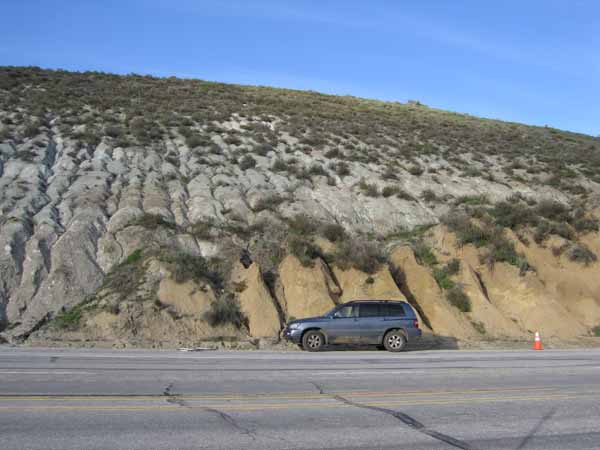
Hwy 5 at Gorman
SEARCH FOR MORE PHOTOS
Google: San Andreas fault crosses highway
Google: San Andreas fault
These links might show some photos from the movie (which I have not seen) but you can check out the source of these photos and see if its from the movie or real?
EXCELLENT WEBSITE
http://www.sanandreasfault.org/
Some of the photos on this page I borrowed are from
http://www.sanandreasfault.org/Pictures.html
ASTROLOGICAL QUAKE PREDICTIONS history of
I am a long time EARTHQUAKE PREDICTOR and sidereal astrologer.
I have online proof that I predicted the quakes before they happened
http://archure.net/astr/prediction200605.html
My predictions are based on (at the bottom of the page see link): find out when Sun is square, conjunction, or opposition to Neptune, then find out when the Moon swings into square, conjunction, opposition with Sun and Neptune, and usually the quakes happen within 24 hours prior to that time. All long ago submitted to Kate Hutton and Lucy Jones at Cal Tech U.